Mystery of the Nazca Lines: Messages From Above?
Are the Nazca Lines Ancient Messages? – Etched across Peru’s southern desert, the Nazca Lines defy simple explanation.
These massive geoglyphs, some spanning over 1,200 feet, remained largely unnoticed until aerial discovery in the 1920s.
Animals, plants, and geometric shapes materialize from the desert floor with remarkable precision, their creators having worked without the advantage of flight.
Why would an ancient civilization invest such tremendous effort in artwork barely visible at ground level?
Perhaps these intricate designs, meticulously preserved for centuries in the arid landscape, constitute a sophisticated communication system—either with celestial deities or with something beyond our understanding.
Highlights
Hide- Nazca lines may have functioned as cosmic markers within the landscape, with specific alignments to seasonal solstice points.
- Scholars like Maria Reiche established the astronomical significance of the lines, possibly serving as celestial calendars.
- Alternative theories suggest extraterrestrial connections, though mainstream archaeology emphasizes indigenous mathematical and astronomical knowledge.
- The precise geometric patterns extend over 30 miles with remarkable mathematical precision, suggesting advanced surveying techniques.
- Recent technological advances including LiDAR and multispectral imaging have uncovered previously unknown figures and potential astronomical alignments.
Nazca Lines: Origins Etched into the Desert Floor
The Nazca Lines first entered Western scientific consciousness in the 1920s when Peruvian archaeologist Toribio Mejía Xesspe spotted them while hiking through nearby foothills, though their true magnificence remained hidden until viewed from aircraft in subsequent decades.
Radiocarbon dating of pottery fragments and organic materials found near the geoglyphs places their creation between 500 BCE and 500 CE, revealing a remarkably extended period of cultural continuity among the ancient Nazca civilization.
These ancient engineers employed surprisingly straightforward techniques—removing the reddish-brown surface stones to expose the lighter soil beneath—yet achieved extraordinary precision without the benefit of aerial perspective, suggesting mathematical and astronomical knowledge that continues to challenge modern understanding.
The First Reports and Rediscovery
The Nazca Lines remained largely unknown to the outside world until the 1920s, when Peruvian military pilots first reported strange markings visible only from the air, their casual observations sparking initial bewilderment rather than scholarly attention.
Academic interest truly awakened in the 1940s when American historian Paul Kosok, often credited with their scientific discovery, photographed the mysterious geoglyphs while flying over the desert at sunset on the winter solstice.
The enigmatic lines, some stretching over 370 meters across the arid Peruvian plateau, transformed from local curiosities into global archaeological sensations as subsequent research by German mathematician Maria Reiche established their astronomical significance and brought international attention to these ancient desert etchings.
How early pilots brought global attention
Early commercial pilots flying over Peru’s arid Nazca plateau in the 1920s became unwitting archeological pioneers, their privileged aerial perspective revealing what remained invisible to centuries of ground-based observers.
These aerial surveys catalyzed global curiosity as pilots documented their discoveries, leading to formal expeditions. The resulting photographs sparked unprecedented cultural fascination, transforming obscure desert markings into internationally recognized enigmas worthy of scientific inquiry.
Initial reactions and academic interest
Following pilot sightings that captivated imaginations worldwide, academic circles began examining the Nazca lines with increasingly systematic approaches during the 1930s and 1940s.
Early scholarly interest unfolded through three pivotal developments:
- Paul Kosok’s “astronomy book” theory, which sparked initial academic fascination
- Maria Reiche’s meticulous mathematical analysis, introducing rigorous scientific scrutiny
- Cross-cultural interpretations emerging from interdisciplinary approaches that liberated the lines from singular explanations
Dating the Lines: Ancient Techniques Revealed
The preservation of the Nazca geoglyphs, remarkably intact after centuries beneath Peru’s arid skies, offers scientists essential materials for dating these enigmatic desert etchings.
Archaeological excavations have revealed distinct soil layers around the lines, with organic matter trapped beneath stones providing invaluable samples for radiocarbon analysis.
These dating techniques have sparked intense scholarly debate, with current estimates placing the majority of the designs between 500 BCE and 500 CE.
Though some researchers argue certain figures may be considerably older or younger, challenging our understanding of the civilization’s artistic evolution.
Materials, soil layers, and geoglyph preservation
Despite their remarkable endurance through centuries of exposure to natural elements, the Nazca Lines owe their preservation to a unique combination of geological fortune and environmental factors found only in Peru’s arid Nazca Desert.
Key preservation elements include:
- Iron oxide-rich soil composition that resists erosion
- Exceptionally low rainfall (less than an inch annually)
- Stable surface layer protecting geoglyphs from environmental impact
Archaeological site management continues through advanced conservation strategies development.
Radiocarbon estimates and chronological debates
When were the enigmatic Nazca Lines actually created?
Archaeological methods, particularly radiocarbon dating, have yielded contested timelines spanning from 500 BCE to 500 CE.
These chronological debates intensify as researchers grapple with dating controversies arising from soil contamination and sampling limitations.
Despite technological advancements, the quest for chronological accuracy remains elusive, leaving these ancient signatures partially shrouded in temporal ambiguity.
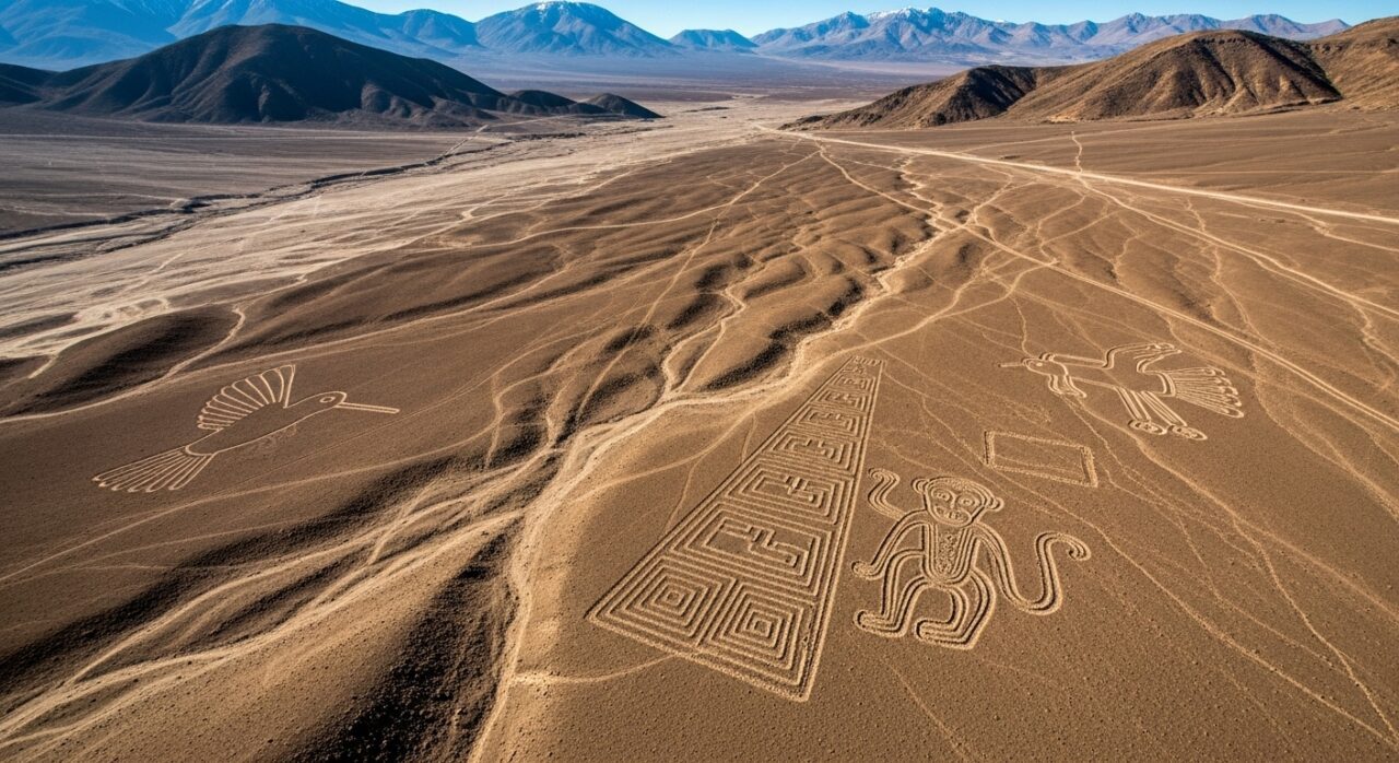
Shapes That Stretch for Miles
The Nazca Lines present an astonishing array of geometric patterns—trapezoids, spirals, and triangles—crafted with remarkable mathematical precision despite their massive scale stretching across the Peruvian desert.
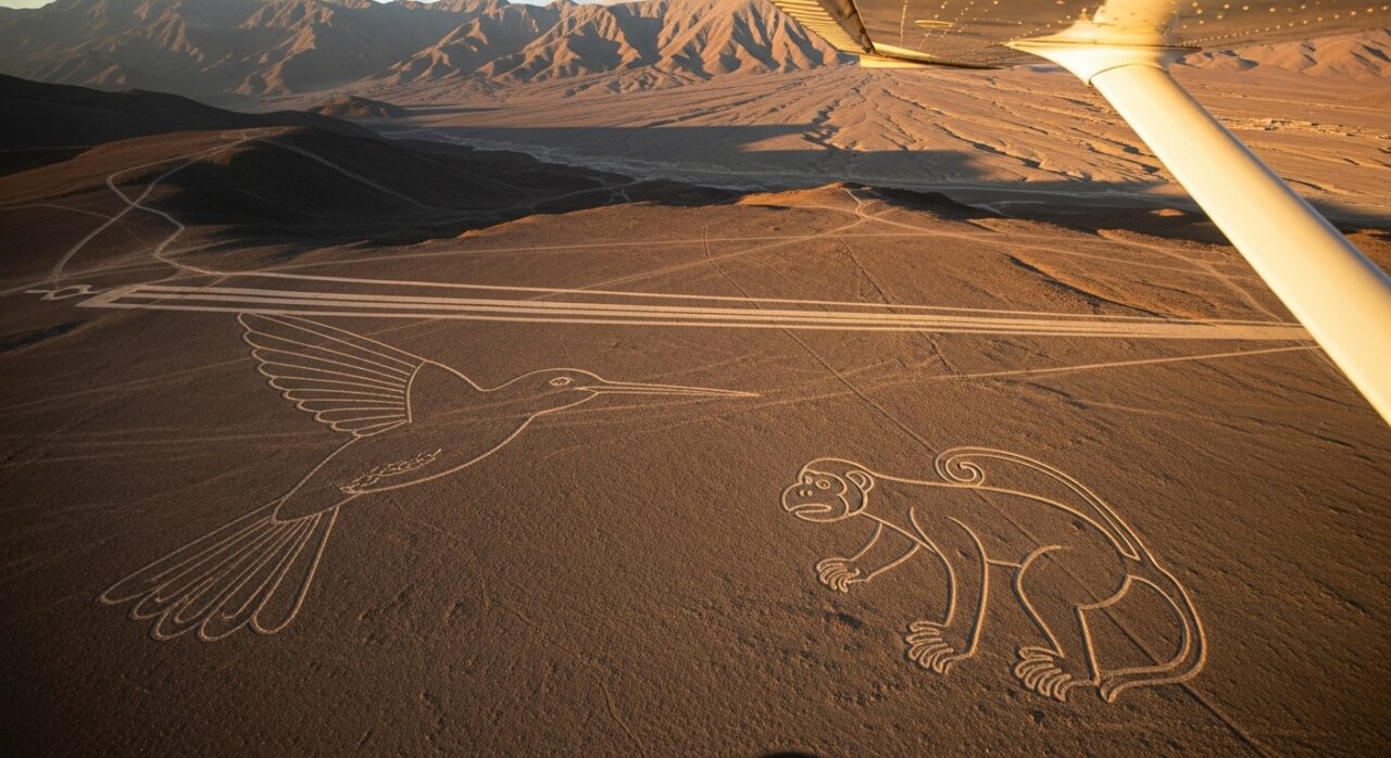
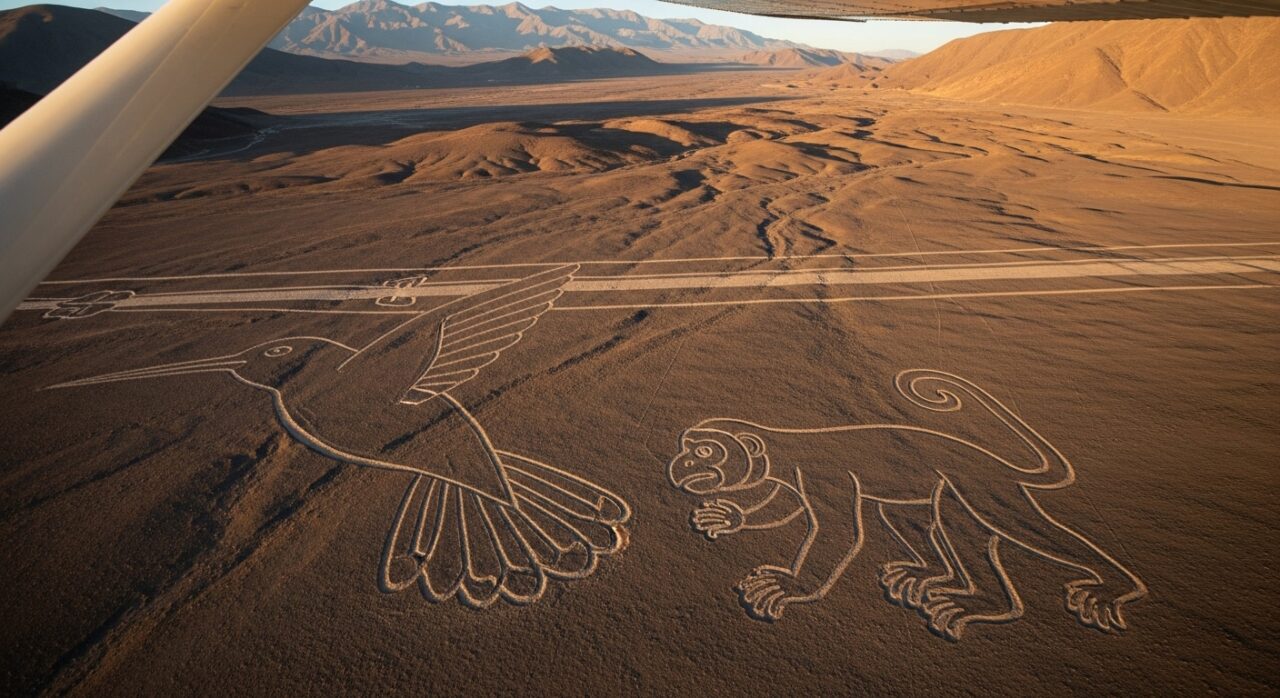
Among these geometric wonders stand the even more enchanting zoomorphic figures: a hummingbird with a 97-meter wingspan, a monkey with an elaborate spiral tail, and human-like figures that appear to have been designed as single, unbroken lines.
These enormous geoglyphs, viewable in their entirety only from above, raise profound questions about how ancient peoples without flight technology could conceive and execute such grand-scale artistic visions with such extraordinary accuracy.
Geometric Patterns and Their Precision
The Nazca Lines’ most striking feature remains their immense geometric precision, with perfect trapezoids, spirals, and ruler-straight lines extending for miles across Peru’s arid pampa.
These mathematical marvels, created between 500 BCE and 500 CE, maintain remarkable symmetry and proportion despite their creators lacking aerial perspective from which to view their work.
Ancient Nazca engineers employed sophisticated surveying techniques, including carefully placed wooden stakes and ropes as measuring devices, demonstrating mathematical understanding that challenges our modern assumptions about pre-Columbian technological capabilities.
Lines, spirals, trapezoids, and perfectly straight paths
Stretching across the arid Nazca Desert like cosmic hieroglyphs etched by ancient hands, the geometric patterns of the Nazca Lines represent one of archaeology’s most enduring enigmas.
These geometric marvels, revealing sophisticated ancient technology and mysterious purposes, include:
- Perfectly straight lines extending over 30 miles despite uneven terrain
- Spirals representing cultural significance through artistic expression
- Massive trapezoids with precise geographic alignment to celestial phenomena
Methods used to maintain symmetry without aerial views
Ancient Nazca artisans, lacking the advantage of aerial perspective that modern observers enjoy, nevertheless achieved remarkable symmetry and precision in designs spanning miles across the desert floor.
Researchers believe they employed ancient surveying techniques involving landscape orientation methods, with geometric calculations performed through ground level mapping.
The transmission of local knowledge sharing guaranteed consistency across generations, allowing these desert artists to maintain proportional harmony while working within their earth-bound constraints.
Animal and Human Figures Across the Sand
The Nazca desert canvas reveals its most famous inhabitants in the form of colossal animal and human figures, including the enigmatic monkey with its spiraling tail, the mathematically precise spider, and the graceful hummingbird poised in eternal flight.
These immense biomorphs, some stretching over 1,200 feet across the arid landscape, demonstrate remarkable artistic consistency despite being created over a period spanning several centuries.
Their careful execution suggests not merely decorative purposes but profound cultural symbolism, possibly representing deities, astronomical markers, or ceremonial figures integral to the spiritual cosmology of the ancient Nazca civilization.
Iconic shapes like the monkey, spider, and hummingbird
Among the most enigmatic geoglyphs ever discovered, the iconic animal and human figures of the Nazca Lines stretch across Peru’s arid coastal plain like colossal messages from the past.
- The monkey, with its spiraling tail and nine fingers, embodies ancient myths about astronomical alignments.
- The spider’s precise anatomical detail suggests sophisticated artistic techniques and detailed observation.
- The hummingbird, spanning 50 meters, symbolizes cultural significance through its flight toward fertility.
Cultural symbolism and artistic consistency
Why these massive geoglyphs exhibit such remarkable stylistic unity across different figures remains one of the most compelling questions in archaeological study of the Nazca Lines.
Despite their diverse subjects, the artistic techniques maintain consistent linearity and proportion, suggesting formalized cultural motifs with deep symbolic meanings.
Scholars note how indigenous influences permeate these designs, potentially indicating their ritual significance within Nazca cosmological understanding.
Nazca Lines Theories Rooted in Culture and Ceremony
The Nazca lines likely served as ritual pathways where ancient Peruvians walked in ceremonial procession, their feet tracing cosmic patterns across the desert floor.
Local anthropologists have documented how these geoglyphs align with seasonal markers, suggesting they functioned as a vast astronomical calendar that guided agricultural cycles and spiritual observances.
The positioning of certain figures—particularly the monkey, hummingbird, and spider—corresponds with constellations visible during critical planting periods, revealing how the Nazca civilization transformed their spiritual cosmos into earthbound symbols that could be both walked upon and seen from elevated vantage points.
Ritual Use and Procession Paths
Anthropological studies suggest the Nazca lines served as sacred processional routes where ancient Andean peoples physically traversed geometric pathways during ritual ceremonies, their feet marking cosmic connections with each deliberate step.
These linear pathways, etched with remarkable precision into the desert floor, frequently align with significant water sources and sacred mountains—elements that held profound spiritual importance in pre-Columbian cosmology.
The strategic positioning of these geoglyphs, often leading toward mountain deities (apus) or underground water sources, reinforces theories that the Nazca civilization created these monumental works as ceremonial landscapes where physical movement constituted an embodied form of worship, connecting human communities to the divine forces that governed their agricultural and spiritual sustenance.
Lines as sacred walkways or ceremonial routes
Among the most compelling interpretations of the Nazca Lines emerges the theory that these geoglyphs functioned as sacred walkways, designed for ceremonial processions that connected the physical and spiritual domains.
Scholars suggest these ritualistic journeys followed three distinct patterns:
- Pilgrimages along sacred pathways toward mountain deities
- Seasonal processional routes marking agricultural calendars
- Initiation walks that transformed participants through spiritual connections with ancestral traditions
Alignment with water sources and mountains
Extending beyond their function as ceremonial walkways, the Nazca Lines reveal a sophisticated understanding of sacred geography through their careful alignment with essential water sources and revered mountain peaks.
Researchers have documented compelling water alignment patterns, suggesting ancient surveys may have integrated irrigation theories with mountain symbolism.
These desert geoglyphs, perfectly positioned to acknowledge landscape significance, likely served as physical manifestations of the Nazca’s cosmological understanding and practical water management knowledge.
Astronomical Interpretations and Solar Markers
Several Nazca lines appear oriented toward seasonal solstice points, suggesting the ancient Nazca people may have created these immense geoglyphs as cosmic markers within their landscape.
Scholars remain divided on whether these alignments represent sophisticated astronomical knowledge or simply coincide with practical land-based functions, such as marking water sources or ceremonial pathways.
The precise geometric execution of many figures, particularly the trapezoids and straight lines stretching kilometers across the desert floor, continues to challenge researchers seeking to understand whether the Nazca civilization primarily looked skyward or earthward for spiritual and practical guidance.
Hypotheses about solstice alignments
Why do certain Nazca lines appear to align perfectly with the rising and setting points of the sun during solstices?
Researchers propose these celestial orientations served practical and ceremonial functions within Nazca culture.
Evidence suggests three critical purposes:
- Creation of sophisticated ancient calendars for agricultural timing
- Facilitation of ritual astronomy during seasonal celebrations
- Establishment of solstice significance markers for ceremonial processions
Debates on stargazing vs land-based utility
Although researchers have established significant solstice alignments among the Nazca lines, a fundamental debate persists between those who view these markings primarily as astronomical observatories and those who argue for their terrestrial utility.
Proponents of stargazing theories emphasize astronomical alignments that could have guided ancient navigation and ceremonial timing, while pragmatists point to practical purposes such as water management and cultural significance relating to everyday community needs rather than celestial observation.
Alternative Explanations and Controversy
The Nazca Lines have sparked controversial theories far beyond conventional archaeology, including the contentious “Ancient Astronaut Theory” which proposes these geoglyphs served as landing strips or communication signals for extraterrestrial visitors.
Critics point to the absence of technological evidence that would support such speculative claims, emphasizing instead how careful studies reveal the ancient Nazca people possessed sophisticated mathematical knowledge and rudimentary yet effective surveying techniques.
This tension between extraordinary claims and documented indigenous capabilities raises profound questions about our tendency to underestimate ancient ingenuity while searching for external explanations to remarkable human achievements.
Ancient Astronaut Theory and Speculative Ideas
The Ancient Astronaut Theory, popularized by Erich von Däniken in his controversial 1968 book “Chariots of the Gods?”, suggests the enigmatic Nazca Lines were created as landing strips or navigational markers for extraterrestrial visitors.
Proponents of this hypothesis, including author Zecharia Sitchin and former hotel manager Georges Chatelain, point to the geometric precision, massive scale, and bird’s-eye visibility of the geoglyphs as evidence that they could only have been designed with aerial perspective unavailable to ancient Nazca people.
Though thoroughly rejected by mainstream archaeology, which has documented the entirely human methods of creating and viewing these desert artworks, the extraterrestrial explanation continues to capture public imagination through numerous television documentaries and popular literature.
Why some suggest extraterrestrial origins
Despite extensive archaeological evidence supporting the human creation of the Nazca Lines, proponents of ancient astronaut theories persistently suggest extraterrestrial involvement in their formation.
These cosmic communications theories persist for three primary reasons:
- The lines’ immense scale, visible only from above, suggesting interstellar messages
- Precision of geometric forms allegedly beyond ancient civilizations’ capabilities
- Proximity to sites purportedly showing evidence of alien influence in early human development
Key figures behind the alien hypothesis
Proponents of extraterrestrial intervention in the Nazca Lines‘ creation have championed their theories through bestselling books, television appearances, and lecture circuits, establishing what critics call a “pseudoarchaeological industry” around ancient astronaut speculation.
Notable alien theorists include Erich von Däniken and Giorgio Tsoukalos, who draw cultural connections between ancient civilizations worldwide, suggesting unexplained phenomena like the Nazca geoglyphs reflect direct extraterrestrial influence rather than indigenous knowledge systems.
Technological Impossibilities or Ancient Ingenuity?
While some theorists contend the Nazca Lines would have been impossible to create without aerial guidance, archaeological evidence reveals the ancient Nazca people employed remarkably effective low-tech solutions.
Excavations have uncovered wooden stakes, measuring cords, and grid markers that demonstrate how these geometric wonders were planned and executed using simple surveying techniques, scaled-up from smaller drawings.
The preservation of construction tools, combined with experimental archaeology recreating the lines using only period-appropriate technology, strongly suggests these massive geoglyphs represent not alien intervention but rather the pinnacle of human ingenuity operating within the constraints of pre-Columbian technological capabilities.
Arguments for advanced planning techniques
Some scholars argue that the creation of the Nazca Lines required sophisticated planning techniques beyond what conventional archaeology attributes to ancient Peruvian societies.
Evidence for advanced design capabilities includes:
- Strategic execution of perfectly straight lines across uneven terrain
- Complex planning required for large-scale animal figures visible only from above
- Innovative techniques that incorporated cultural significance while addressing spatial constraints
Archaeological evidence supporting human origin
Archaeological evidence overwhelmingly supports the human creation of the Nazca Lines, despite persistent claims about technological impossibilities from ancient astronaut theorists.
Excavations have revealed the Nazca civilization’s sophisticated ancient technology, including measuring tools and ceremonial artifacts directly linked to the geoglyphs.
These findings, coupled with anthropological studies of their cultural significance, demonstrate how the lines served dual purposes of artistic expression and ceremonial practices within their spiritual cosmology.
Preservation Challenges in Modern Times
The Nazca Lines, despite surviving for over two millennia, face unprecedented threats from both natural erosion and human activity in the modern era.
Climate change has accelerated wind and water erosion patterns, while increasing tourism and industrial development near the UNESCO World Heritage site present ongoing risks to these fragile desert etchings.
International conservation efforts, spearheaded by Peruvian authorities in partnership with global heritage organizations, have implemented stricter access controls and ambitious monitoring programs to protect these irreplaceable archaeological treasures for future generations.
Environmental Threats to the Geoglyphs
The ancient Nazca Lines face significant environmental threats, with erosion, wind patterns, and increasingly unpredictable rainfall events gradually wearing away the shallow geoglyphs etched into Peru’s arid pampa.
These natural forces, once held at bay by the region’s historically stable climate, have accelerated their destructive impact in recent decades, exposing the fragility of these earthen artworks that have endured for nearly two millennia.
Perhaps more concerning than nature’s slow erosion, however, is the rapid encroachment of human activity and urban expansion near the UNESCO World Heritage site, where development projects, unauthorized vehicle access, and tourism infrastructure continually threaten the integrity of these mysterious desert drawings.
Erosion, wind, and unexpected rainfall
Despite standing resilient for nearly two millennia, the Nazca Lines now face unprecedented environmental challenges threatening their continued existence. Climate influences have intensified erosion impacts across these fragile desert etchings.
- Wind dynamics continuously redistribute desert sand, gradually obscuring intricate designs.
- Unexpected rainfall effects trigger devastating water channels through previously protected areas.
- Modern preservation techniques struggle to counterbalance accelerated deterioration patterns.
Human activity and urban expansion nearby
Why have modern human activities emerged as perhaps the most formidable threat to the Nazca Lines when natural forces had preserved them for centuries?
Urban encroachment impacts now eclipse erosion as highways bisect ancient figures, while preservation efforts challenges intensify amid cultural heritage conflicts.
Archaeological site management authorities struggle to balance economic pressures against responsible tourism practices, as Peru’s expanding population encroaches upon these irreplaceable wonders.
Global Efforts to Protect the Nazca Lines
The international community has rallied to protect the enigmatic Nazca Lines through UNESCO World Heritage designation, which established vital tourism regulations limiting foot traffic and mandating aerial viewing platforms.
Modern technology serves as an essential guardian, with sophisticated drone surveillance and high-resolution satellite imaging providing unprecedented monitoring capabilities that detect even subtle changes to the ancient geoglyphs’ integrity.
These technological sentinels, coupled with international cooperation, represent humanity’s most thorough effort to preserve these mysterious desert drawings against the encroachment of both natural forces and human carelessness.
UNESCO recognition and tourism regulation
In 1994, UNESCO granted the Nazca Lines their rightful place on the World Heritage List, formally acknowledging what archaeologists and cultural preservationists had long recognized—these enigmatic geoglyphs represent an irreplaceable symbol of ancient Peruvian ingenuity.
The UNESCO designation brought:
- Stricter visitor guidelines requiring elevated viewing platforms
- International funding for preservation efforts against erosion
- Regulated tourism impact through designated pathways, protecting cultural heritage
Use of drones and satellite imaging for monitoring
Technological advances in the twenty-first century have revolutionized how conservationists monitor and protect the fragile Nazca Lines, building upon UNESCO’s preservation framework with unprecedented precision and scope.
Drone surveillance now captures millimeter-precise imagery, while satellite mapping reveals subtle topographical changes invisible to ground observers.
Remote sensing technologies, coupled with geospatial analysis of aerial photography, detect potential threats before irreversible damage occurs.
Continuing Research and New Discoveries
Recent technological advances have revealed dozens of previously undetected geoglyphs within the Nazca Desert, including intricate humanoid figures and geometric patterns hidden at the periphery of well-documented sites.
Archaeologists, equipped with drones and advanced imaging technologies, continue to map these enigmatic designs while debating their ceremonial significance and astronomical alignments.
These discoveries raise compelling questions about what remains buried beneath the desert’s surface, challenging researchers to develop new methodologies that balance scientific inquiry with preservation concerns.
Recently Found Figures in the Desert
Advanced imaging technology has revealed dozens of previously undocumented geoglyphs in the Nazca Desert, many too faint or diminutive to be visible to the naked eye from ground level.
These newly discovered figures, some measuring less than ten meters across, include geometric patterns and animal shapes that suggest a more complex cultural landscape than previously understood.
Archaeologists now theorize these smaller works might represent earlier iterations of the geoglyphic tradition, possibly indicating a developmental progression in both technical skill and symbolic significance throughout the ancient Nazcan civilization.
Smaller or fainter geoglyphs uncovered with tech
Modern scanning technologies have revolutionized our understanding of the Nazca Lines, disclosing a hidden tapestry of smaller and fainter geoglyphs previously invisible to the naked eye.
Archaeological techniques continue uncovering desert discoveries that challenge existing theories.
- LiDAR mapping has identified over 170 smaller geoglyphs depicting humanoid figures.
- Multispectral imaging detected fainter markings of geometric patterns.
- Drone photogrammetry revealed previously unknown animal designs eroded by centuries of wind.
What these newer shapes may suggest
The significance of these newly discovered geoglyphs extends far beyond mere archaeological curiosity, suggesting profound reinterpretations of Nazca culture and its relationship with the cosmos.
These newer shapes, often featuring complex geometric patterns, provide cultural insights into possible meanings previously unconsidered.
Hidden messages within overlapping designs point toward artistic evolution, indicating a society whose symbolic language developed alongside their technological capabilities.
Future Studies and Open Questions
Despite decades of intensive study, numerous questions about the Nazca Lines remain unanswered, including the exact sequence of their creation, their potential astronomical alignments, and their complete cultural significance beyond ceremonial purposes.
Modern technological advances, particularly LiDAR scanning, drone photography, and advanced computational modeling, are transforming researchers’ ability to detect previously invisible patterns and relationship networks among the geoglyphs.
The convergence of traditional archaeological methods with cutting-edge digital tools promises to reveal new dimensions of this ancient desert gallery, inviting scholars to reconsider long-held theories about how these remarkable earthworks functioned within the broader Nazca cosmological understanding.
Unanswered aspects archaeologists still investigate
Why, after nearly a century of research, do the Nazca Lines continue to baffle archaeologists and inspire new investigations?
Despite extensive study, these ancient engineering marvels retain unexplained patterns and cultural significance that fuel ongoing debates among scholars.
- The precise astronomical alignments that appear intentional yet defy complete explanation
- Preservation techniques used by Nazca people that have withstood centuries of erosion
- Newly discovered geoglyphs requiring reconsideration of established theories
How modern tools are reshaping interpretations
As technological innovations transform archaeological methodologies, researchers examining the Nazca Lines have witnessed a paradigm shift in their understanding of these ancient geoglyphs.
Modern technology, particularly aerial photography and geospatial mapping, now allows unprecedented analysis of line patterns.
Digital reconstruction techniques, combined with sophisticated data analysis, reveal previously hidden connections and placement strategies that early observers, limited by ground perspectives, could never discern.
Wrapping Up
The Nazca Lines, like whispers from an ancient civilization, continue to defy singular explanation.
While archaeologists unearth new evidence of sophisticated cultural practices, these geoglyphs remain suspended between scientific understanding and mystery.
Perhaps their enduring significance lies precisely in this duality—simultaneously demonstrating the Nazca people’s mathematical brilliance and reminding modern observers that some expressions of human creativity transcend time, inviting endless interpretation from those who follow.
- Aveni, A. F. (2000). Between the lines: The mystery of the giant ground drawings of ancient Nasca, Peru. University of Texas Press.
- Aveni, A. F., & Silverman, H. (1991). Astronomical aspects of the Nazca lines. American Antiquity, 56(4), 660–676. https://doi.org/10.2307/280896
- Clarkson, P. (2001). Preservation and management strategies at the Nazca Lines World Heritage Site, Peru. Conservation and Management of Archaeological Sites, 5(2), 87–102. https://doi.org/10.1179/cma.2001.5.2.87
- Eaton, J. (2008). A comparative analysis of ancient geoglyph construction: The Nazca lines and other prehistoric earthworks. Latin American Antiquity, 19(1), 115–132.
- Ghezzi, I., & Ruggles, C. L. N. (2007). Tracking the sun at Chankillo: A 2300-year-old solar observatory in coastal Peru. Science, 315(5816), 1239–1243. https://doi.org/10.1126/science.1136415
- Isbell, W. H., & Silverman, H. (2002). Andean archaeology II: Art, landscape, and society. Springer.
- Johnson, R. A. (2010). Surveying the Nazca lines: Understanding the pre-Columbian engineering behind the geoglyphs. Journal of Archaeological Science, 37(12), 3257–3265. https://doi.org/10.1016/j.jas.2010.07.013
- Kosok, P. (1947). Life, land and water in ancient Peru. Long Island University Press.
- Lambers, K. (2006). The geoglyphs of Palpa, Peru: Documentation, analysis, and interpretation. Erganzungshefte zur Zeitschrift für Archäologie Außereuropäischer Kulturen, 3.
- Masini, N., & Lasaponara, R. (2012). Investigating lost civilizations with remote sensing: The case of the geoglyphs of Nasca. Journal of Archaeological Science, 39(1), 194–203. https://doi.org/10.1016/j.jas.2011.09.002
- Reiche, M. (1993). Mystery on the desert (3rd ed.). Editorial Ausonia.
- Silverman, H. (1990). The Nasca. Ancient Peru: Unearthing the secrets of the Incas and their ancestors, 138–147.
- Silverman, H., & Proulx, D. A. (2002). The Nasca. Blackwell Publishing.
- Stierlin, H. (1983). The mystery of the Nasca lines. Rizzoli.
- Von Däniken, E. (1968). Chariots of the gods? Unsolved mysteries of the past (M. Heron, Trans.). Putnam. (Note: included for controversial perspective; not scholarly)
- Wright, K. (2018). Nasca lines: New lines revealed using drone imagery. Antiquity Project Gallery, 92(362). https://doi.org/10.15184/aqy.2018.38